Once again, we got a later start than we hoped. Though we weren’t out incredibly late, we didn’t get to sleep until around 11 last night. We wanted to be up and on the road by 6am to possibly beat the traffic rush at Rocky Mountain National Park, but that didn’t happen. Yesterday took a lot out of us, and rather than using the bonus time from not having to pack up our tent to get an early start, we opted for more sleep. We managed to get on the road by about 8:30.
What Might Have Been

Beyond our last day in Yellowstone, we couldn’t make reservations at Grand Teton National Park, and we didn’t have any at Rocky Mountain National Park. This gave us the option of spending either two nights at Grand Teton and one at Rocky Mountain, or vice versa. We ended up staying the two nights in Grand Teton. Our original plan was to spend one night—last night—camping in Rocky Mountain, which would give us the better part of the day to hike in the east side of the park near Bear Lake.
However, on our first full day at Grand Teton, we wound up at the emergency room in Jackson because I was dehydrated. We had planned on hiking up into Cascade Canyon. Since we didn’t want to leave without a hike, we decided to extend our time at Teton—and we dropped the plan to camp one night in Rocky Mountain National Park. All of this resulted in having time only for a basic drive through. Now with the late start, my original goal of hiking near Bear Lake looked like a major long shot. I often wonder how things would have gone if we hadn’t juggled things around so much, because I had drank enough water like a good boy! C’est la vie…
Reality In the Rockies
I can’t really complain too much…for being a couple of first-timers doing this on our own, well over a thousand miles from home in strange, rugged lands, without our moms or dads or any locals by our side to help us avoid dangers, we’d seen and done an awful lot without dire consequence in the last two weeks! Adventure awaited us yet again as we set out for our fifth and final national park for this trip. Up until 9 days ago, Becky and I had only ever seen 6 of the 47 national parks in the Lower 48—and in this one trip we’d almost doubled that number and seen places we’d only ever read about in books, seen on TV, or dreamed about. I always thought this would be a lot harder…and I’m really glad we decided to do this!
Anyway, we started out east on US-40 with me driving to the next town, Steamboat Springs, which was almost an hour away. We traversed high desert for most of yesterday, so I was hoping for some trees today. The maps depicted national forests just a few miles to the east of Craig, but yesterday we saw nothing of these woodlands on our drive in from Wyoming, not even in the distance. Most of the drive from Craig to Steamboat Springs followed the Yampa River and a railroad line. It was pretty country but not spectacular, with a lot more greenery than anything we saw last night. The scenery really started to improve just as we entered Steamboat Springs.
Steamboat Springs
While Craig seemed more like a blue collar town where the locals worked at growing, mining, or making things, Steamboat Springs instantly struck me as a larger version of Jackson, Wyoming…a fancy ski resort town with a lot of tourist money flowing through. On the mountain in the distance, you could see grassy green ski trails between the trees, although we were not yet close enough to make out the lifts. The architecture as well screamed “rustic ski resort!”. You could tell they worked hard to appeal to international tourists too, with all their speed limit signs in both imperial and metric units.
The plethora of retail along the main road had me hoping for a decent place to score a quick breakfast. Also, the amount of water I’d been drinking made the stop totally necessary. We still had nearly two hours of driving to get to Rocky Mountain National Park, and this was the most sizeable community for quite some distance. We drove through most of town when I finally just pulled into a Starbucks. One of their La Boulange breakfast sandwiches would do the trick for me, and Becky was happy to get coffee and dig into our trail mix.
Our Big Fat Bag of Potato Chips

Among the many things we packed for our trip back home in Northern Ohio were two bags of Trader Joe’s Hawaiian-Style potato chips. Somewhere in South Dakota, Becky noticed that she couldn’t get them to fit into one of the plastic food bins in the trunk. By the time we’d reached Cody, Wyoming, the bags were puffed up like a balloon, and Becky wondered what had gone wrong with the chips! She knew that sometimes a bag would spoil and expand, but she couldn’t believe it had happened so fast. She opened one of them, and the chips seemed perfectly fine…but she was still mystified as to what was going on.
When Becky brought this to my attention, I asked her what happens to air pressure at higher elevations. I saw the light bulb go on instantly! Back in Ohio, we live below 1,000 feet, but by the time we were in Cody, we were around 5,000 feet, with much thinner air, causing the air in the air-tight bags to expand. Our last bag of chips had survived some pretty high elevations so far—most of our time in Yellowstone was over 7,000 feet, and we’d crossed Powder River Pass in the Bighorns at over 9,500 feet. Now came the ultimate test—Trail Ridge Road—which at one point surpasses 12,000 feet! When I rummaged for my camera in the back of the car, as Becky was taking over on driving, I remembered our our big fat bag of potato chips and put them in the back seat so we could hear when it pops. Either it was gonna blow today or not at all!
Rabbit Ears Pass & US-34

On the road again, we ascended from 6,700 feet in Steamboat Springs to over 9,000 feet over Rabbit Ears Pass. The highway hugs the side of a mountain most of the way up, giving way to spectacular views of lakes below, and snowy peaks far off into the distance. About halfway between Steamboat Springs and the entrance to Rocky Mountain National Park, US-40 and US-34 are marked as the Colorado River Headwaters Scenic Byway. The two roads fork just before the town of Granby, where US-40 heads southeast to I-70 and Denver, and US-34 proceeds northeast into the park.

For several miles, US-34 follows the resort areas along the shores of Lake Granby and Shadow Mountain Lake. The lakes were rather large with giant mountains rising up on the opposite sides. There were a number of marinas, motels, vacation houses, and mobile homes all along the highway. We crossed the fledgling Colorado River a couple of times here, as the road closely follows it.
Finally we passed beyond Shadow Mountain Lake, turning northward and more uphill, and saw a sign that we were entering Rocky Mountain National Park. The busy resort area gave way to forest and meadows on both sides of the road. All around, everything was green and peaceful.

Rocky Mountain National Park
Not far down the road we came upon the Kawuneeche Visitor Center, which is just outside the Grand Lake Entrance Station. We stopped here so Becky could get our friend’s National Park Passport book stamped, and of course, so we could use the restroom. The visitor center was small, but extremely busy. It was close to noon, and every family was there with their kids. One room had a relief map of the park and its features. You could press a button and get one to light up—but it was of little use with the never-ending stream of kids repeatedly pushing all of the buttons out of shear boredom.
While Becky looked for the stamp, I looked for a park ranger. I suppose it was wishful thinking, but I asked if it was realistic to get a hike in at Bear Lake and still be back in Denver by 5:30pm. She told me that driving and parking there at this time of day is no picnic, and that we’d probably run out of time for a hike before we found our way to a trailhead. She suggested options along Trail Ridge Road…some were along the Colorado River, while others were in the alpine areas of the park. She warned us to be careful about lighting in the alpine areas, since there’s no cover.

For some reason I still thought we should head for Bear Lake, but I was more open now to checking out something in the high country, especially the Alpine Visitor Center. The west side of the park was green with lots more trees, but Bear Lake was on the more interesting rugged east side of the park. Besides its ruggedness, the east side was also within a two-hour drive of Denver, which made it exceptionally popular. The alpine regions through the center of the park sounded like a worthy compromise.
Ascending the Trail Ridge
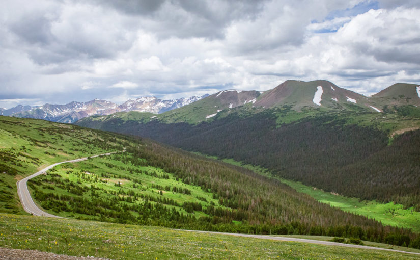
So we got back on the road, which for about 10 miles passed through forest land, with the Colorado River on our left, and mountains towering to our right. The Colorado at this point is just at the small beginnings of the mighty river it turns into downstream. The valley narrows gradually until the road takes a hairpin turn to the right and begins ascending a long switchback that surpasses two miles above sea level!
Along the way were spectacular pulloffs, but we were unable to stop—not so much due to time, but due to urgency. Since we were going up a road that topped out over 12,000 feet in elevation, I had been drinking plenty of water to thwart a repeat of my dehydration episode at Grand Teton National Park. So even though I took care of things back at the Kawuneeche Visitor Center, I had to go pretty badly…again.
We passed right on by the Fairview Curve and on to our first restroom opportunity at the Lake Irene Picnic Area. After relief, I felt a bit woozy and just told Becky I wanted to sit for a minute and get used to the altitude or whatever was bothering me. I hadn’t eaten a lot so far today, and we’d just gone up a switchback with numbered U-curves with a full bladder, so who knows for sure if it was one of these factors or the altitude.
It didn’t seem like we were two miles high up where we were. I looked around but didn’t find Lake Irene…I just saw a bunch of cars and a few picnic tables with people kicking back for lunch. We were still subalpine with trees surrounding the little meadow here. The only indications you were very high were the millions of hungry mosquitoes trying to eat you before the cold came back and killed them, and your body feeling funny and telling you to slow down.
I decided to eat a few slices of bread to calm my stomach. Becky was chomping on trail mix or almonds we had with us. All of a sudden, POP!!!
We looked at each other and thought for a second, and then we began giggling. Our science experiment in air pressure had ruptured at just short of 11,000 feet above sea level! The bag had ripped open along its bottom seam. We laughed some more about how low the air pressure must be, and started snacking on the chips too.
A few minutes later we felt jolly enough to continue up the road. About a mile down, we crossed the Continental Divide for the eighth and final time. After a few miles more, we ascended above the tree line to the alpine elevations—where only the smallest plants and grasses manage to survive. Another switchback later, we arrived at the Alpine Visitor Center, way up at 11,796 feet.

Alpine Visitor Center

The parking lot was jam-packed, but we got lucky and found a spot after just one circuit around. The visitor center and a cafe were on one side of the lot, while the other side had a short hiking trail to the top of a nearby peak. We were finally on top of the Trail Ridge itself with some wonderful views, and yet we could still see Trail Ridge Road climbing up even higher to our east!
The thinner air was definitely cooler, so we added some layers before walking around. There were snow-capped peaks to the south and the east. We could definitely feel the altitude, but it mostly only made me feel sluggish. I took everything nice and slow to be safe.
On the far side of the visitor center was a deck overlooking a half crater that sloped down the entire side of the mountain. There was still snow melting in the shadow at the very top. When you looked far enough down, you saw that water collected at the bottom to form a stream that eventually turned into a creek further down. You could see cars making their way up alongside the stream to the visitor center on Old Fall River Road, which was the original road traversing the park. It was still a dirt road, now only running one-way, and was replaced by Trail Ridge Road.
Inside the visitor center was an old-school mercury barometer. I had trouble finding the mercury inside the tube and asked a ranger what the reading actually was—he said 18.8 inches! Wow! That’s less than two thirds of what low air pressure is where I come from!
Trail to the Top


By now we were more acclimated to the air pressure and I asked Becky if she was interested in taking the Trail to the Top, which is the short hiking trail I mentioned earlier. There were still lots of people going up and down there, and the weather was fairly calm, though it was overcast. Becky said she’d love to go up, and so we started up, taking each step nice and slow. Us flatlanders can get winded pretty easily up here, so caution seemed like the smart way to go. The trail was steep, but not crowded, so I stopped several times to let my camera smell the wildflowers. Nothing grew more than a couple of inches above the ground unless it was a rock. I was so enthralled with this foreign environment and the views, that I was just as interested in this as in Bear Lake—except that I was already here.
Before we set out, I heard there were elk hanging around on the side of the mountain. As we neared the top, we saw two sets of bodyless antlers sticking up, so the elk were still there. Even though the tiny plants up here take years to grow because of the short growing season in this harsh climate, elk and bighorn sheep still make their way up here to graze in the summer.
From the very top we had a full view of the elk chewing their cud on the mountainside, the Alpine Visitor Center and Old Fall River Road below, and high mountain tops and deep valleys in every direction. A sign said, “Elevation 12,005 feet”, so we were now more than 200 feet above the parking lot! I took some photos of course, but raindrops started to fall with some ugly clouds moving closer, so it seemed like we should start back down. I didn’t want to be a human lightning rod up there!
By this point we felt pretty good with the thin air, so going down was a piece of cake. I felt better than I’d felt all day. After one last pit stop, we got back in the car and continued on our way.


Snow-Capped Knuckles by the Snow-Capped Peaks
Getting up to the Alpine Visitor Center was a white-knuckle drive up a rather narrow mountain road. What comes afterward is positively frightening!!! The road in many places completely lacked a guardrail, and the terrain was just rugged open grassland sloping down for hundreds of feet. After the grassy slopes there were often cliffs, where only birds and mountain goats dared to tread. In some areas you might get lucky and catch the treeline before a precipitous drop. It was beautiful country, but it left you feeling really vulnerable with the total lack of cover or trees to break a slide down the shoulder!
I told Becky that I didn’t know if she was nervous or not—but that I very much appreciated her staying on the road, and that whatever speed she liked was fine with me! She replied, “Oh I’m terrified at the moment, and I’m only doing 20, so I’m pretty good right now!”
Wow…what a lucky guy I am to have a girl who can drive through this without totally panicking! I told her that this was scary for me too, but I was trying to keep my comments to myself so I didn’t make her more nervous.

Along this stretch of Trail Ridge Road were more elk and more trails to cliff overlooks. These looked incredible, but we’d have to save them for another time. As it was, I guessed that we had just enough time to finish crossing the park and make our way to my aunt’s house for dinner at 5:30.

Eventually we made it to the switchback that took us down from the ridge and on to the split, where US-34 continued north to join up with Fall River Road, and US-36 began and headed east to the mountain resort town of Estes Park. We switched drivers here and I finally got a cell signal that allowed me to fire up a navigation app to guide us into Denver. Waze confirmed that my timing was about right, although it said we would be about 15 minutes late. It was around 3:45 and we had about two hours to cross Denver to its largest suburb, Aurora.
Heading into Denver
Estes Park was a picturesque little mountain town. It literally sits right at Rocky Mountain National Park’s front door, so there’s lots of hotels, shops, and restaurants for the tourists along with plenty of traffic. After Estes Park, I honestly thought we’d be right next to the foothills and plains, but we were actually still up in the mountains. The drive along US-36 wound its way through a beautiful canyon for several miles before emerging in flatter country around the town of Lyons.
My original plan was to follow US-36 through Boulder and on into Denver, but with rush hour beginning and us already being a bit late, I opted for the fastest route Waze offered. This took us around Longmont on CO-66 to I-25. This part of our drive had a decidedly farm-meets-suburb feel, and the land was pretty much just flat. This was our first brush with American suburbia since probably southern Wisconsin or maybe a neighborhood around Rapid City. The Western states really aren’t very populated, so the Denver area really sticks out since it is the only urban oasis with big-box retail, shopping malls, big buildings, and a major international airport, for hundreds and hundreds of miles. It felt weird to us after spending the last week in mostly wilderness!
When we made it to I-25, I thought we’d have it made in the shade since we’d be heading toward the city while most people headed out. I was wrong! Traffic on this stretch was actually worse going south than north for some weird reason. My original thought was to cross through the heart of Denver, but Waze told me that would add 15-30 minutes to our drive, so we opted for Denver’s outerbelt toll road, E-470. I was apprehensive about this, as I had no idea how the tolling worked, and I had no idea if the tolls were reasonable or crazy expensive. I guess we were going to find out!
It turns out that E-470 collects tolls by looking up your license plate and sending a bill in the mail. I had no idea how that would work since we were in a rental car. The tolls listed on the signs also sounded quite a bit higher than most. In Ohio, we have only one toll road, the Ohio Turnpike. We also have E-ZPass, which is used by almost every toll road and toll bridge east of the Mississippi except for Florida. In Ohio, the tolls are already pretty low compared to other states, plus I get a discount for using E-ZPass. It costs me about $8 to drive 150 miles on the Ohio Turnpike to the Indiana state line. As I counted the tolls along the way, I figured it would cost me about the same just to drive only 30 miles on E-470! Oh well…at least the tolls kept the congestion down, and as a result I didn’t have traffic problems.

We did have rain problems though…and how! As we left Estes Park, we saw deep blue clouds heading south with us toward Denver. I was hoping we wouldn’t drive into them, but this looked inevitable. When we finally got out of the traffic jam on I-25 and onto the ramp for E-470, the torrents came. There were times when the rain came down so hard that I couldn’t go more than 30mph without hydroplaning.
The weather started to clear by the time we got close to Denver International Airport, and it was almost sunny again by the time we got to I-70. It was dry all the way from the freeway to my aunt’s house. She was tucked away in a quiet little neighborhood of condominiums in a newer part of Aurora that probably didn’t even exist the last time I was in Denver to visit 29 years ago.
At last we’d be off the road and in a real bed in a real house with familiar faces for three whole days! Tonight we were going to have shishkabobs with my aunt, cousin D.J., his girlfriend Leona, and later my cousin Kelli and her husband Jamie. For the next three nights we’d sleep in Kelli & Jamie’s guest room further out in the suburb of Lone Tree. Tomorrow we’d spend the day with friends in Colorado Springs. Friday, we’d peruse Downtown Denver during the day, and have a cookout with my family in the evening. I was looking forward to seeing some cousins I hadn’t seen in almost 15 years. On Saturday we’d start working our way east toward home and the conclusion of our trip…