Last Stop with Laura
So, after another violent Great Plains storm (albeit in much more secure conditions) and our car already packed, we emerged from our covered wagon to much cooler but drizzly weather. The misty haze was not looking good for my photographic aspirations today! The forecast showed the rain holding on for just a little longer in De Smet, and that there would be a general clearing trend where the sun might come out and burn off the fog. Becky and I each got showers this morning, since it would have more long-lasting effects than if we’d showered the night before with the 85-90 degree heat and humidity. The humidity in South Dakota was nowhere near as high as what we had experienced before we left Ohio, but it was enough to make you move a lot slower so you didn’t overexert yourself in the heat. Now that the temperature had dropped to 65-70 degrees, everything except the haze was peachy.
We got a fairly early start, getting out of the Ingalls Homestead around 8am. We headed into De Smet and to the local coffee shop, Ward’s Store. Interestingly enough, this was the site of Charles Ingalls’ store, and in the original building that rose in its place after he sold it and moved out to his homestead. Becky was really glad to have gotten coffee here, since now she’s been to every place where Laura lived in De Smet.
We then continued south on SD-25, making our way down to Mitchell, which is only about an hour away. We planned to see the famous Corn Palace, and I hoped to score a quick breakfast. Ever since we’d left De Smet, it had been horribly foggy, drizzly, and hazy. The rain had let up completely by the time we’d reached Mitchell, but the fog lingered.
The World’s Only Corn Palace

We got breakfast at a hip restaurant called Cafe Teresa. The place seemed to be loaded with college students, who I’m assuming were from Dakota Wesleyan University. It was easy to overhear bits of conversations about finals, classes, and professors. Becky and I both ordered eggs and toast, which hit the spot..and so off we went to see the Corn Palace.


The Corn Palace is the main tourist draw in Mitchell, which has about 15,000 residents and a rather quaint and decidedly Western downtown. The building is decorated on its exterior by thousands or maybe millions of ears of corn, color coordinated to depict western scenes of cowboys, buffalo, stagecoaches, and Indians on the front and sides of the building. Unfortunately, it took us a bit to make sure we had actually found it because it looked much less flamboyant than the pictures we’d seen. Apparently they were in the process of replacing the domes on top and had run into a delay because the new domes weren’t strong enough to hold up to South Dakota’s wind (which Becky and I have noticed is quite substantial). Also, it appeared that they were updating parts of the building’s exterior, which they do every year anyway because it’s probably a good idea to slap a fresh coat of corn on the building to keep it from peeling.

Becky and I proceeded inside “The World’s Only Corn Palace”, hoping for a more satiating indoor experience. There were lots of exhibits inside about corn, the history of the Corn Palace (reaching way back into the 1890s), and then there were doors…turns out through the doors you could see that the Corn Palace had a lot in common with San Francisco’s Cow Palace and the Detroit Area’s Palace of Auburn Hills—for it was a small basketball arena where a giant souvenir and gift shop had been set up. I didn’t figure it for an opera house, but I have to admit that without having done any research that in the back of my mind when I saw the general shape and size of the building, I wondered if in fact this was a basketball arena.
It seemed like a very nice place to see a game. It was likely that it hosted games for either the Dakota Wesleyan University or the local high schools. But either way, the clock was ticking and we had to move on to Badlands National Park, which was about 3 hours away on I-90.
You GOTTA SEE South Dakota!


I’d like to take this opportunity to recognize South Dakota for a couple of things. First, Mitchell was my first indication that South Dakota really was a great place to analyze advertising gimmicks, because between what we saw here and what we saw later that day in Wall, it was readily apparent that South Dakota took the art of a tourist trap to a refined art form! There were signs and buildings and old trucks and cars and dinosaurs in front of billboards all along the interstate that really were sights in their own right and really made it tempting to stop a lot along the freeway and check this stuff out.

Second, the speed limits in South Dakota often seemed to actually make sense! In Minnesota and most other states, you drove 55mph, maybe 60 if you were lucky in remote two-lane state highways—we hit the SD state line, and voila—65mph! When we first got on I-90 in Mitchell, we had to check our eyes at first—”Speed Limit 80″—AWESOME! So thank you, South Dakota, for admitting that you might as well be able to drive fast on the roads here because there are so very few cars, the visibility is great, and it takes so very long to reach someplace.
Another reflection I have to make about South Dakota is that I didn’t expect it to have so many trees—in fact, I didn’t expect it to have any at all without at least a creek nearby, since it is in the Great Plains—and the Great Plains is a great big huge prairie that just doesn’t have the rainfall to really grow trees. Apparently the main reason why there are so many trees is because of the Homestead Act, which allowed you to earn your 160 acres of land through growing enough trees on your claim…and probably because people who aren’t used to vast open grasslands prefer to have lots of trees to break up the scenery (and did we mention wind?). Personally, I’m all about diversity and history, so I was excited at the prospect of seeing a land that was just covered with prairie and all the things that come with it! I also think a giant prairie sounds awesome for just grazing cattle, which we saw a lot of actually. Black Angus cows were everywhere, and lots of pieces of property up in the northern part of the state had lakes and sloughs where the cows often congregated to play in the water and drink as well as graze. As we pushed farther west from Mitchell, we started to see a lot more of the open prairie I expected and we got to see fewer trees if any at all.
The Great Plains Are Not Flat
One big misnomer about the Great Plains is that it is all flat. That may be true in places like Illinois or Kansas, but it is most definitely not the case in Minnesota or South Dakota where rolling hills are pretty much the rule.
There are even deep valleys, especially along I-90, with the biggest valley being the Missouri River, which runs right through the state. It was unfortunately extremely foggy when we crossed it, but it was still a site to behold! It seriously was more like crossing an expansive lake than crossing a river, and was actually much much bigger in person! If they had called it part of the Mississippi instead of naming it a whole other river, the Missouri-Mississippi River would be among the longest in the world, and from what we saw, it had enough water to prove it!

Crossing the Missouri was significant for another reason too—prairie dogs—of which we had seen none so far along the entire prairie we had crossed. I asked someone about that in De Smet, and was told that all the prairie dogs were located on the other side of the Missouri River. The locals here hate them, because as this gentleman said, prairie dogs with their burrowing “just destroy the land”. We were still looking forward to seeing some though, as they are an animal unique to the American West.
Another feature I noticed were steep escarpments to the south along the freeway, and sometimes there would be giant protruding chunks of land in the middle of the prairie. We were pushing closer to the Badlands, and so it seemed there were small little badlands appearing more frequently in the distance to our south along the freeway.
When we got on I-90, I told Becky to let me know if she wanted me to drive, since we’re about to get on a long stretch of mostly straight freeway where highway hypnosis can set in. About an hour or so away from Badlands, Becky said she was starting to have trouble, so I had her pull off a few exits down the road so I could finish my last blog entry. It was my first taste of legally zipping along at 80mph, on a freeway in the middle of the open prairie.

We were just a few miles away from our exit for Badlands National Park on I-90 where we pulled off the freeway at a scenic overlook. As we headed up the hill to take in the view of the expansive prairie all around us and the Badlands in the distance to the Southwest, two people seemed engrossed in some sort of spectacle taking place on the ground. When we got close enough, you could see two little pieces of poop rolling up the hill being pushed by little dung beetles who were happy to have scored dinner!

Entering Badlands National Park


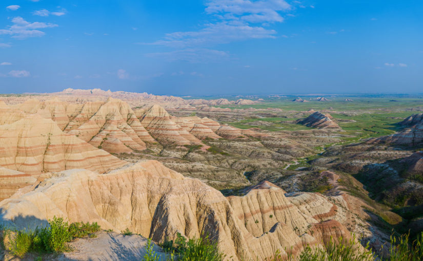
We pressed on into Badlands National Park, a place where neither of us had ever been, and our first national park of the trip. On the map it looked as if you got off the freeway and BOOM there’s the Badlands. Reality however, was that it was still nearly ten miles until we reached the park entrance. Since we planned on visiting four national parks with entrance fees on this trip alone, we ended up purchasing an annual pass for $80. The total for entering each of these with just an individual park pass would be $105, so I recommend the annual pass if you plan a trip like this, at it saves you a substantial amount of money!
Entering the Badlands was like entering another world! You’re on the prairie and then there are sharp layered outcroppings of rock that look like teeth made of mud sticking straight out of the ground. Some were as tall as a person, and some were hundreds of feet high, while plenty of others were in between. Cedar Pass was positively awesome, where the road descends at least a couple hundred feet down an escarpment that revealed how big these Badlands really were when you could see them from the south. It was almost like going down a great big step over a monster’s bottom teeth and into its mouth.

The Ben Reifel Visitor Center, the Cedar Pass Lodge and cabins, and the Cedar Pass Campground, where I had made a reservation, were all at the bottom of the drop. Becky and I were still nervous about setting up a campsite again on the prairie due to our harrowing experience two nights before, but setup went rather painless. There are two sections of the campground, an RV loop with electric sites, and a tent loop with a shower house in the middle and nonelectric sites. Oddly, it seemed many of the RV sites were set down into the prairie, with more shelter from the wind, while the tent sites are on a rather flat spot that is mostly exposed to whatever blows in. Thankfully, the winds were way calmer than at De Smet, although it was a bit breezy. Most of the fog had burned off, but it was still rather hazy because of what I assumed was the still-raging forest fire in Canada. The forecast did call for calming winds in the evening and overnight, so we took solace that our tent was unlikely to blow away.
Off we went to the Cedar Pass Lodge to get lunch. The restaurant there had a fairly simple menu, with beef and buffalo burgers, chicken, and pulled pork sandwiches, along with a small salad bar. The burgers were delicious Black Angus beef, while my sweet potato fries could have been better. (I think I am spoiled by the sweet potato fries back home at The Rail!)

At the visitor center, I checked in with the park ranger to see if there were any animals or insects we should beware of when hiking, and to get a recommendation on a trail or two. The ranger said that the only animals to watch out for are prairie rattlesnakes, but that it is exceptionally unlikely that we’d get bit. They usually rattle before striking, giving plenty of warning to back away, and I believe he said that in the last ten years, only 3 people had ever been bitten by one. And in one of those incidents the snake didn’t even inject any venom—it was a freak accident where a lady walked past the snake without realizing it and then backed up to it. When I asked which trails had the best vistas, he recommended the Notch and the Door Trails, which we passed on our way into the park. He also said that if there’s something you see and you want to go check it out—feel free to go off the trail and check it out—we don’t mind that here.
Exploring the Badlands
So Becky and I took the shorter and easier of the two trails, Door, and climbed up on a couple of the big piles of dried mud they call Badlands to check things out. The views were spectacular, with Badlands reaching out as far as you could see in one direction, and with open prairie popping up in spots.


Apparently the name “Badlands” originated with the Lakota, who called the area “mako sica”, or “land bad”. Later, French traders coming from Fort Pierre to Fort Laramie called them, “les mauvais terres pour traverse”, or “bad lands to cross”. If I were trying to get somewhere, I certainly wouldn’t want to cross this terrain to get where I was going, as it stretches for miles and it looks like it would be easy to get lost in. For us, crossing was a blast! Although it did help that there were bright yellow stakes in the ground marking the trail so we knew where to go. This particular trail would still be of little use to a French trader, however, as it ends overlooking a large canyon that has no water and looks impassable.


Another striking part of the prairie and the Badlands in its midst were all the flowers, especially the black-eyed susans. They were everywhere and really added a wonderful touch to the scenery.
From the Door/Window/Notch parking area we followed the Badlands Loop Road for its 27-mile run through the most popular part of the park and on up to I-90 and into Wall. The loop road offers sweeping views of the Badlands, climbing around two or three other passes up and down the escarpment. Sometimes you’re next to prairie on one side, and badlands on the other side…but both sides always had black-eyed susans.
There are also plenty of animals along the way, where we saw pronghorn antelope and mule deer very close to the road. The rule in any of the national parks is that if you see people randomly stopped on the road, there’s probably wildlife within sight, so stop and see what they see!


Around one curve we saw a car stopped, but it was not immediately clear what they were observing. We pulled over and at last saw prairie dogs! There were several holes very near the road with the little rodents, about the size of a squirrel, hanging out and chirping at each other. Sometimes they made a chirping that sounded like the smallest little dog barking, but for the most part, we weren’t sure why they were called prairie “dogs” because we thought they sounded more like dog squeak toys. I suggested to Becky that maybe the guy who named them died or got distracted in mid-sentence telling someone they were “prairie dog toys” and never got to say “toys” at the end of his sentence.


Have You Dug Wall Drug?


So onto Wall, and the “famous” Wall Drug we had seen signs for since first entering I-90 200 miles ago back in Mitchell. A Facebook friend of mine told me that there are signs everywhere for miles and miles for Wall Drug along the way west, but I didn’t realize how much of an understatement that was until we got on I-90. The place had taken billboard marketing to a whole ‘notha levol…so this place better be good!
We passed I-90 and drove just a bit into Downtown Wall. The town itself is really not all that big, but the downtown for several blocks is ALL Wall Drug! The place is almost like an amusement park and a mall mashed together, with shops, a cafe, a soda and ice cream shop, a playground with sprinklers for the kids, and even an animatronic T-Rex. I got their homemade hard red raspberry ice cream which was smooth and awesome. Becky got their traditional 5 cent coffee, which she said was just drip coffee, but it was good coffee, especially for 5 cents. Apparently you put a nickel in a wooden box and you fill up your cup. She said she would have had more if she’d have had another nickel.
In Wall, we refueled, restocked the ice in the cooler (by the way, don’t look for a park or picnic table in Wall, as there weren’t any I could find readily available), and headed back to the Badlands on I-90, at 80mph.
Sleep on a Quiet Prairie
We entered the Badlands at dusk, just after sundown, and the peaks had become grey shadows against the blue night sky. We settled into our tent for the night with calm winds, a perfect temperature and a serene campground with no fireworks or campfires (too much of a risk for prairie fires) and no roughty campers.
It was a perfect night to sleep in a tent, and it was the best night’s sleep I’d had in days. The next morning we would wake up to the Badlands all around us and pack up for the Black Hills to visit Mount Rushmore and our second national park, Wind Cave.